
Bentonville, Arkansas is home to 60,000 people and the largest retailer on earth.
In 2019, Walmart’s leaders decided to consolidate its workforce to a few select cities and to build a new headquarters in Bentonville. But Walmart’s leaders knew those jobs wouldn’t be enough to tempt those surely talented enough to find jobs in elite coastal cities to move to — or stay in — Bentonville. Instead, the city itself must be attractive — it would need to provide a high quality of life that punches above its small-Arkansas-city weight class in order to recruit, retain and engage its talent.
Enter: Sam Walton’s grandsons, Tom and Steuart, who are like the Medici dynasty, if the Medicis lived in Northwest Arkansas and funded paths and trails, instead of poisoning aristocrats. They’ve directed upwards of $74 million from the family’s foundation to building 163 miles of paths and trails in and around Bentonville. The trail system is for both leisure – it kickstarted a booming mountain bike tourism industry, including a prestigious race called the Big Sugar Classic – and for transport. The city, neighboring municipalities, and the state parks have built their own miles of trails too, to bring the total miles of paved and dirt trails in Northwest Arkansas to over 500.
The return on these and other investments is clear:
- The bicycling ecosystem in Northwest Arkansas generated an impact of $159 million
- Homes a quarter mile from a paved trail sold for $6,300 more in 2018, on average, than homes one mile away from the trail.
- Bicycling helped people in Northwest Arkansas avoid $59 million in healthcare costs in 2022.
Our region has at least 400 miles of paved and dirt trails (according to my back-of-napkin math counting the Centennial Trail, Beacon Hill, Mount Spokane State Park, Riverside State Park, and the Trail of the Coeur d’Alenes), but each is seen as an individual park rather than part of a cohesive system.
Yes, Bentonville has loads of trail mileage, but more importantly, it has a trail network. The network, known as Oz Trails, is expanded, branded and looked after by a nonprofit organization, NWA Trailblazers (not to be confused with the Portland basketball team). The Trailblazers create interactive trail maps of the network, organize trail clean up days and group rides, host community cycling classes, host a platform for trail reports and build new trails across the region.
An example closer to home
2,000 miles northwest of Bentonville and 180 miles west of Spokane, in Central Washington, lies the Methow Valley, a picturesque river valley just east of the North Cascade mountains dotted with a handful of small towns. Like Northwest Arkansas, its residents have developed a natural resource that results in the region punching above its weightclass: it’s the home to the largest Nordic Trail system in North America.
In the summer, this stellar trail system is used by mountain bikers, hikers, runners and horse riders. While its primary use cases are recreational, it’s used for non-motorized transportation too.
But unlike Bentonville, it has no Medici-like sponsor. It only has the combined efforts of residents, governments, and nonprofits over the course of decades. One of them, Methow Trails, is a nonprofit similar to the NWA Trailblazers – it maintains a master plan for the system, builds new trails, brands the network, produces trail maps and organizes events. It coordinates across every level of government, and with businesses in the area and other nonprofits like the Evergreen Mountain Bike Alliance.
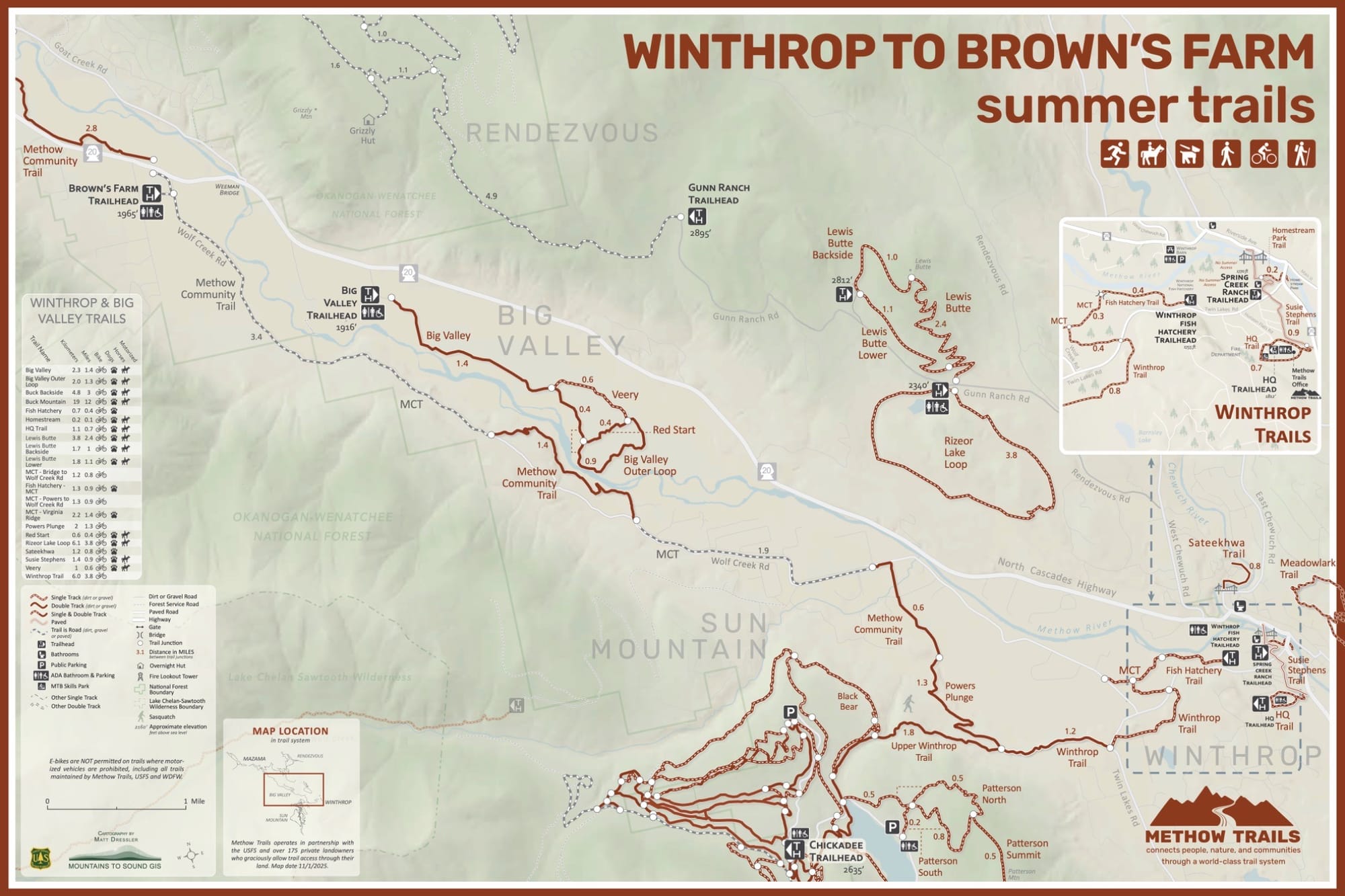
The network is split across federal Forest Service, federal Fish & Wildlife, state Department of Natural Resources, state Fish & Wildlife lands and over 175 private properties – Methow Trails has organized long-term agreements with landowners to protect the public’s ability to use the trails!
The economic impact of Methow Trails is similar to that of Oz Trails, but scaled as expected for a smaller population:
- It generates $17.6 million annually for the local economy
- It supports the employment of 260+ people. Year-round trail usage means these jobs also tend to be year-round.
- Homes within a quarter mile of a trail tend to sell for about 10% more.
Not bad for an area with less than 7,000 residents.
I have not been to Bentonville, but I rode the Methow Trails a few weeks ago and I can’t stop thinking about them.
Not only is the trail system impressive, the structure around the system is what makes it shine: Methow Trails has distributed magazines and trail maps to local businesses throughout the region and created trailheads. It’s also posted signage that identifies the trails, provides wayfinding, and grades them along a technical scale so you never end up on a trail you don’t have the bike or skills to ride.
Why it works
NWA Trailblazers and Methow Trails’ status as independent organizations is their superpower. As a transportation advocate and observer of local government, I cannot imagine our local governments coordinating with each other, let alone federal and state governments, on anything at all. Even coordinating something simple, like the trail system’s branding, would take decades, or fail entirely. Creating integrated master plans, building new trail segments that cross municipal boundaries and striking agreements with private landowners seem like nigh impossible tasks to coordinate through that many layers of bureaucracy.
Having an independent organization, run by residents and blessed by each level of bureaucracy to work seems much more achievable. Rather than hoping for the system to be loved and maintained by passionate government employees that somehow stick around through budget cuts and election cycles, the nonprofit remains a steady driver of the project via dedicated staff and board members. (Not that nonprofits are easy to run, but at least they can remain focused on their specific remits in a way I haven’t seen in local governments, who have many other topics and projects to work on.)
What’s the point of all this though?
Namely, I want Spokane to be a nice place to live. Doubling down on its natural beauty isn’t just a nice idea – it’s a way to do economic development that lasts and isn’t dependent on courting one large employer that may leave. It’s how we avoid the fate of Pennsylvania mining towns. It’s courting employers and employees, universities and students, events and tourists.
A greater Spokane trails system would surely attract tourism, which is great, and trail networks like Oz Trails and Methow Trails definitely do that, but more importantly, they make their communities great for the folks who already live there. They make it easier and more fun to exercise and commute, and increase the value of property in the area. They provide spaces to host outdoor events like community rides and races.
What am I hoping for? Picture this.
A branded trail network throughout the Inland Northwest. Integrated trail maps that cross municipal boundaries are critical – after all, only city planning nerds among us know where one city ends and the county starts.
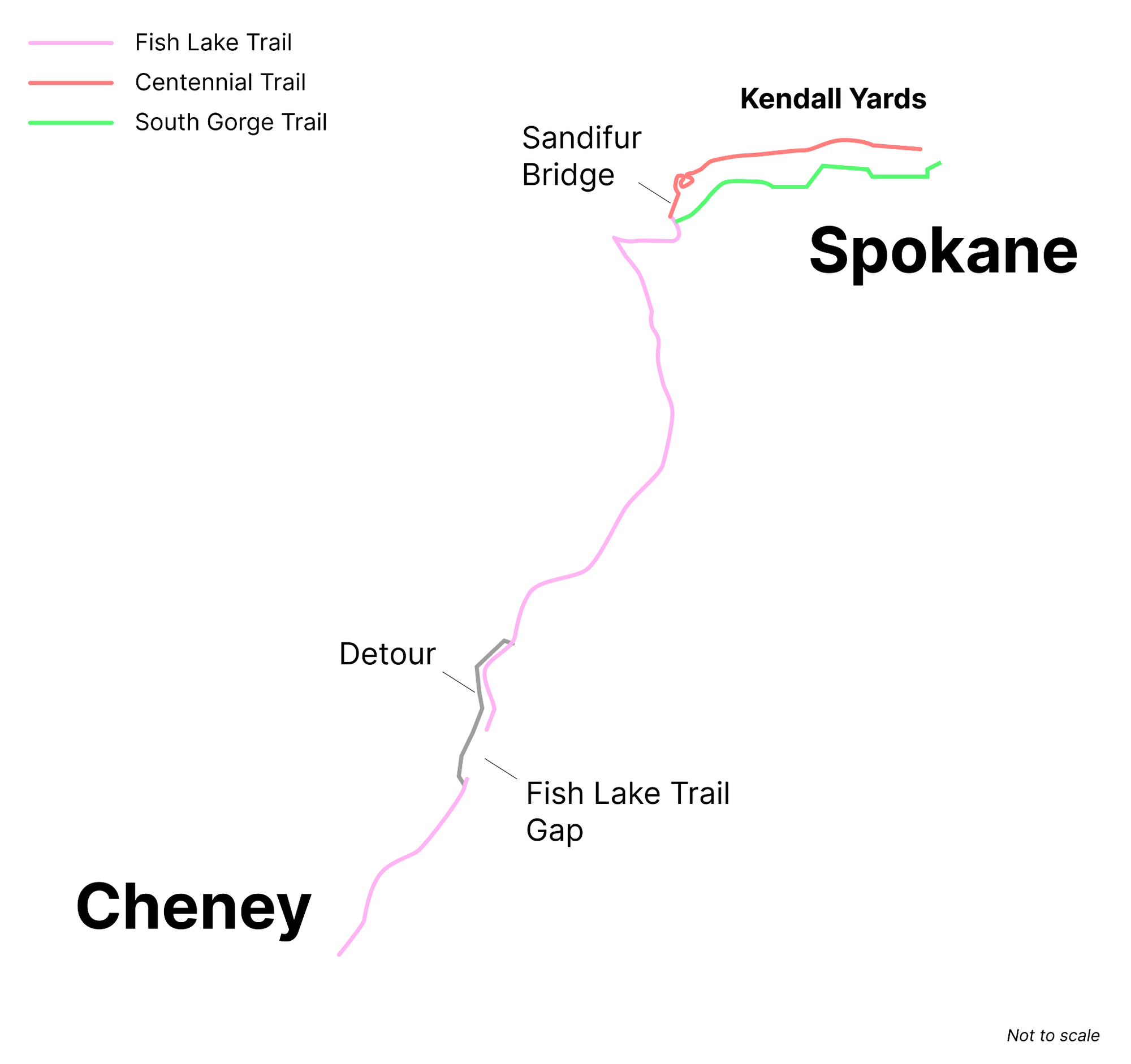
It’s not important that a cyclist on the Fish Lake Trail knows that she just exited Cheney and she’s now in the county. What is important is that she knows the trail exists, how to detour onto Cheney-Spokane Road to reach the northern portion of the trail, confirmation she’s made the detour correctly, how far she is from the Fish Lake - Centennial Trail intersection and that crossing the Sandifur bridge would bring her into Kendall Yards, but staying on the South Gorge Trail would be a more direct route into downtown.
The massive advantage we have is that these trails already exist and are actively being expanded.
The greater Spokane area already has many miles of paved and dirt trails: the Appleway Trail, Trolley Trail, the Bluff Trails, Riverside State Park, Beacon Hill and many more. Spokane also has miles of greenways and protected bike lanes, like those on Riverside Avenue downtown and Illinois Avenue.
And this year, the city of Spokane is extending the path along Sunset Boulevard, the state is extending the Children of the Sun trail, and Spokane Valley is building a new trailhead for the Centennial Trail. And we already have community orgs that sponsor our trails and look after them, like the Friends of the Centennial Trail and Friends of the Bluff.
But notably, the system is owned, maintained and expanded by multiple cities, counties and states, and streets/transportation departments and park departments at every level of government. (While we have the Spokane Regional Transportation Council doing admirable work to integrate across various government bodies, its focus is too broad in that it includes car travel and too narrow in that it tends not to work on parks and dirt trails.)
Although not perfect nor complete, a trail network already exists. Importantly, it needs a name so it can be referred to as a local perk on Zillow listings, job descriptions, university websites, and city commerce Instagram ads. It needs a brand so that when you arrive at the start of an unassuming dirt trail, you know you’re in the right place, or so that there’s something to Google when you first notice a trail in your new neighborhood.
A modest start to creating something like Oz Trails or Methow Trails of the Inland Northwest would be:
- A brand (name and logo)
- Trail maps, both that span the region and focus in on subareas, starting online then printed later.
- A simple website
- Permission to print signs and post them throughout the network
- The actual printing and posting of signs, starting in Spokane and expanding outwards
Then, partnerships with other nonprofits and expanded levels of government.
I want to hear from you: who is already doing this work? Who is interested in helping? Who has an idea for a name? Drop me a line at bikeroutehelp@range.com


