
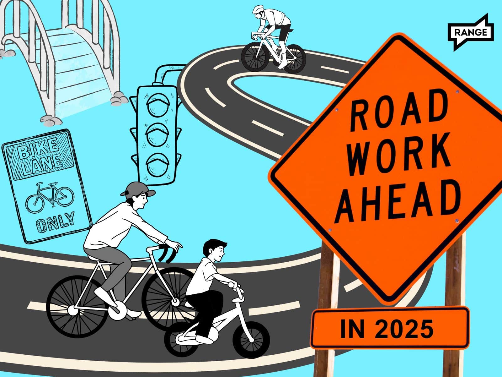
Two weeks into 2025, and I’m already excited for what’s coming in active transportation infrastructure. But before we look at what’s coming in 2025, let’s rewind to celebrate the long list of infrastructure wins we had in 2024.
Within Spokane:
- The Children of the Sun Trail was extended south to Euclid Avenue.
- The Post Street Bridge was finally finished (reconnecting the Centennial Trail!), along with the South Gorge Trail.
- Howard Street got a jersey-barrier protected bike lane (it’s a short section, but it’s precisely the type of treatment needed to encourage more folks to ride).
- Spokane Falls Boulevard through the University District now has buffered bike lanes.
- Traffic calming cycle 10, which consisted of five lighted crosswalks and a whopping 17 other micro-projects, was completed.
- Most of the six small projects in traffic calming cycle 11 projects were finished, aside from a few speed feedback signs that will be installed this spring.
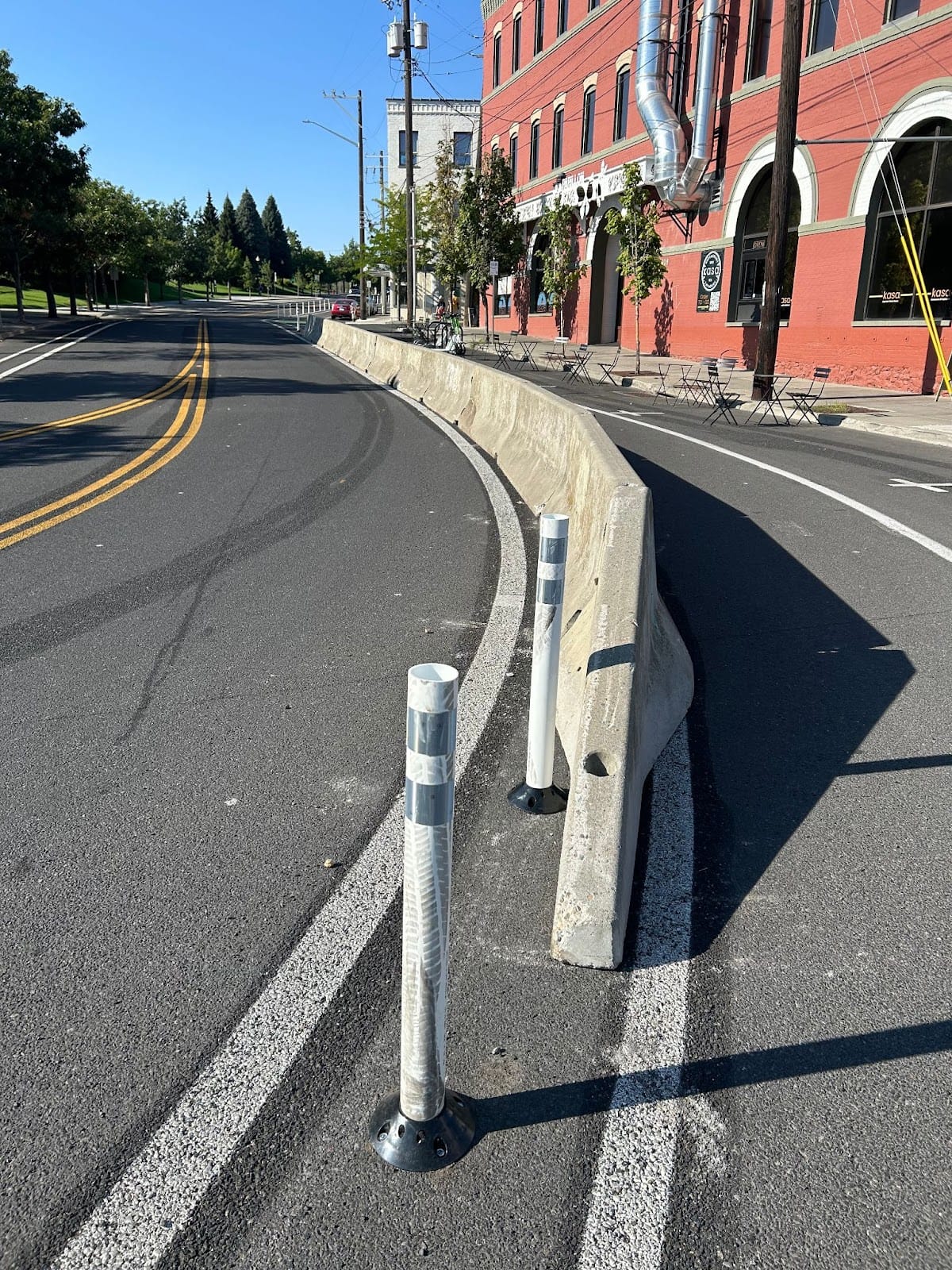
The Howard Street jersey-barrier protected bike lane. (Photo by Lauren Pangborn.)
Elsewhere in Spokane County:
- The first 14 miles of the Centennial Trail were rebuilt.
- A shared use path was built on 10th Avenue in Airway Heights.
- Hatch Road in Colbert also got a new shared use path.
- The county built a new bike route from Greta Avenue to Whitworth University.
- Bike lanes were built on Bowdish Road in Spokane Valley.
Based on the county’s Transportation Improvement Plan, 2025 may not turn out to be the banner year that 2024 was, but there are at least a handful of projects to get excited about.
Four great bike projects set for completion in 2025
1. Sunset shared-use path/cycle track
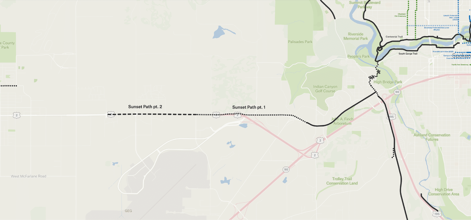
In this two part project, the city of Spokane intends to extend the shared use path running along the north side of Sunset Boulevard. It currently stretches west from Government Way to roughly Royal Street (although it becomes an unprotected two-way cycle track the further west one rides).
By the end of 2025, the city plans to extend it 1.8 miles to Spotted Road. And by the end of 2026, the city will extend it another 1.5 miles to Deer Heights Road, for a total of nearly five miles – providing a route from Airway Heights nearly into downtown Spokane.
I hope it will be at least curb-protected for its entirety due to very high vehicle speeds, but I can’t find evidence of any protection in the plans. I hope for the sake of its usability, it will have at least a curb.
2. Maxwell buffered & protected bike lanes
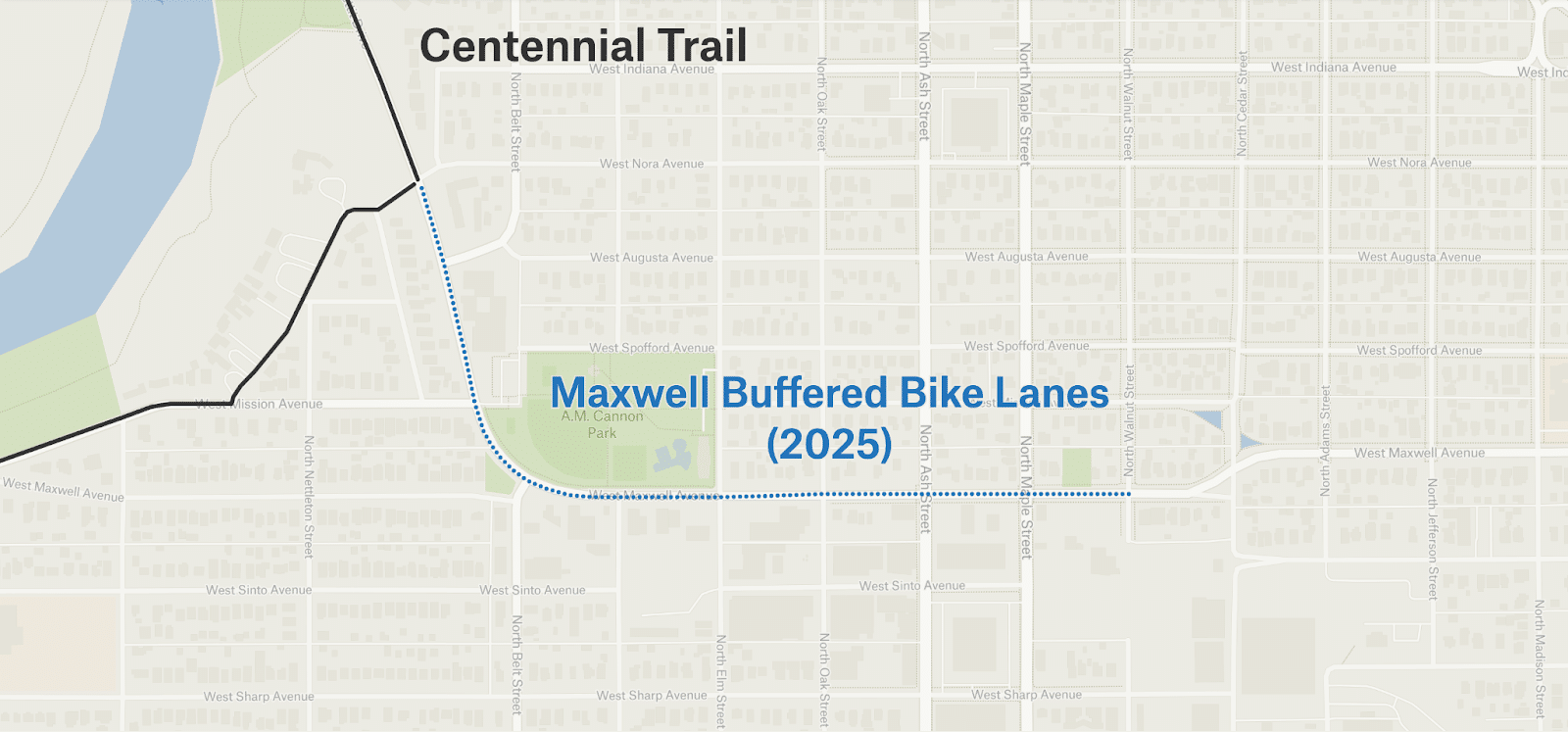
The city’s transportation plan calls for buffered and protected bike lanes on Maxwell Avenue from Pettet Drive to Walnut Street in West Central.
A buffered or protected bike lane – one that feels safe and comfortable for all ages and abilities – on Maxwell Avenue is needed, as there is no east-west cycling route north of the Centennial Trail and south of say, Garland Avenue. Any routes in this area contend with the active transportation barriers that are the loud, high-speed and high-traffic Ash and Maple streets.
Unfortunately, plans I’ve seen for the project include a few blocks of bike lanes that are neither buffered nor protected – and worse, those lanes are smack dab in the drivers’ side door zone.
If you care about the bike lanes being comfortable and safe for all types of users for the entire length of the project, let your city council member know. I promise they don’t bite!
3. Lincoln Street protected bike lanes
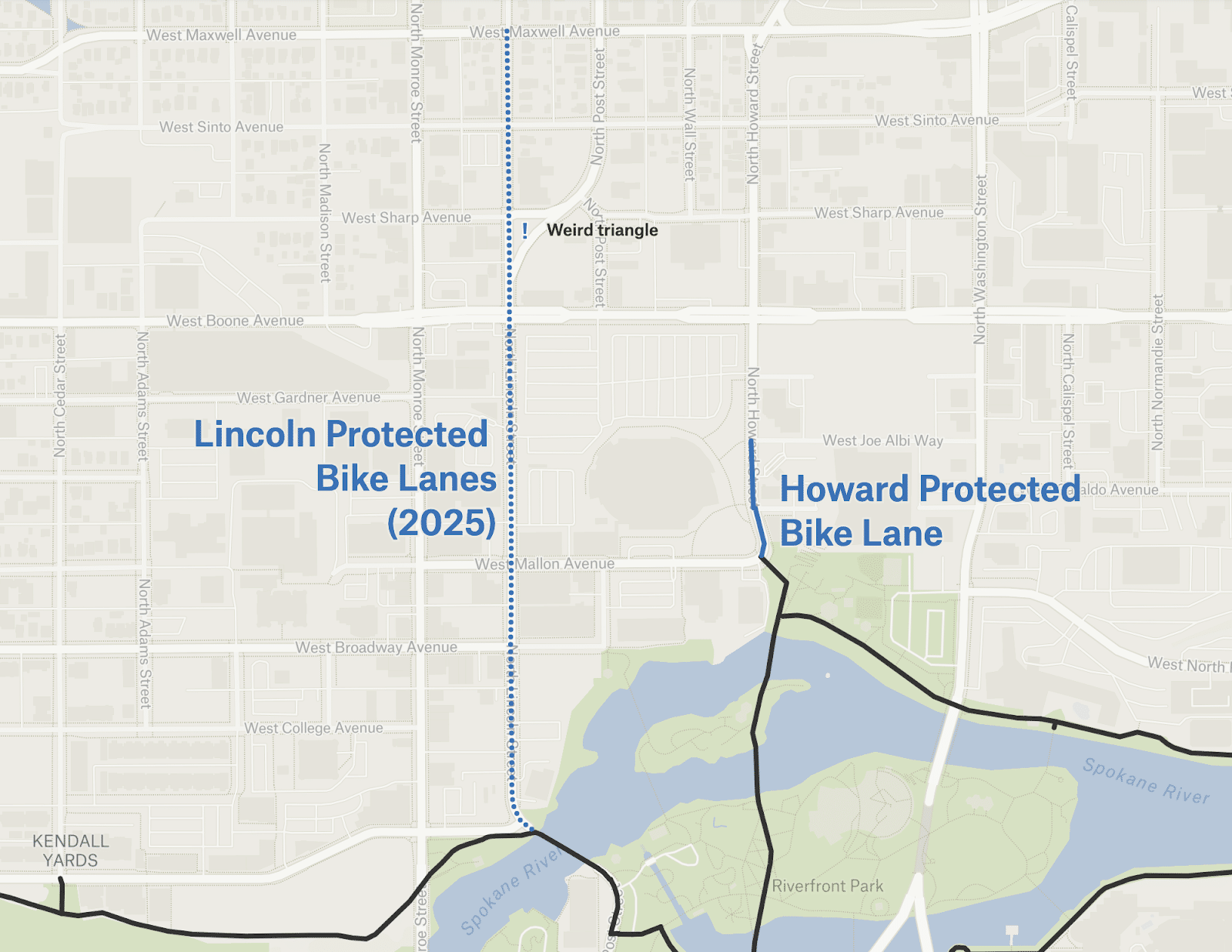
The city plans to restripe, reconfigure and add buffered or protected bike lanes to Lincoln Street between the Post Street Bridge and Maxwell Avenue (both of which have bike infrastructure – don’t we love a network connection).
I’m hoping that weird triangle where Lincoln Street, Sharp Avenue, and Post Street meet will get less awkward and safer for those traveling by bike.
If the lanes truly are buffered and/or protected, this should provide an excellent north-south route just one block over from Monroe Street.
This project is funded by the Washington State Department of Transportation’s (WSDOT) pedestrian/bicycling safety program.
4. Children of the Sun river crossing
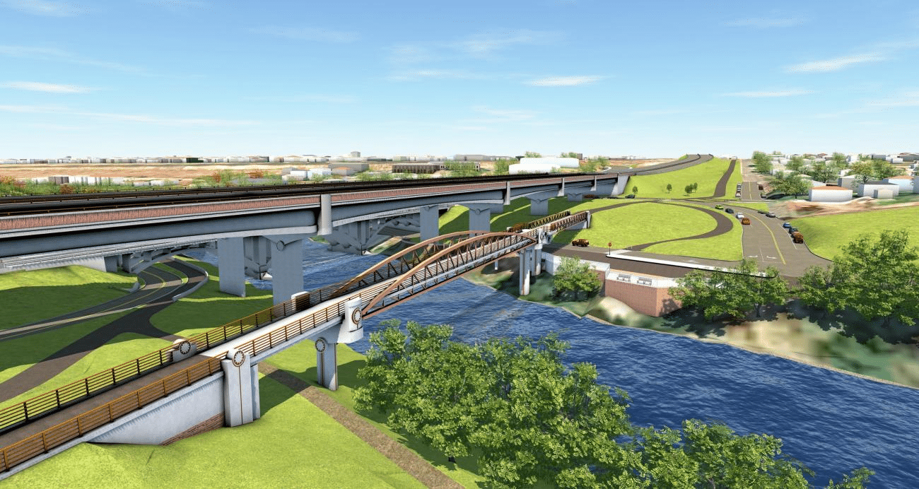
The Children of the Sun Trail river crossing, looking northwest. Source
And now for the project I’m most excited about (🥁drumroll please…🥁) the Children of the Sun Trail river crossing, which is planned to be completed this year! The image above illustrates the nexus of the Children of the Sun Trail running north-south, the Centennial Trail running east-west on the north bank, a path along Riverton Avenue to the west on the south bank, and the future Millwood Trail to the east on the south bank.
This intersection is for active transportation what the North Spokane Corridor/I-90 connection will be for cars, but one of those projects bulldozed homes in East Central and will cost $305 million while the other… certainly did not and will not. I’ll let you guess which one is which.
This pedestrian/cyclist-only bridge will be the only bike-friendly river crossing between the Iron Bridge and the Centennial Trail bridge near Plante’s Ferry, an eight-mile stretch.
But it’s not just the big projects that enable active transport; one needs all the little neighborhood connections too.
Less exciting – but still important – projects
These next few might not seem worth writing home about, but they’re important to the folks around them. Here are the small projects I’ve found that are scheduled for completion in 2025:
- New bike lanes on Barker Road from Appleway Avenue to Sprague Avenue in the valley.
- Widening of the bike lanes on Cascade Way on Spokane’s north side.
- Widening of the bike lanes on Country Homes Boulevard between Wall Street and Division Street, also on Spokane’s north side.
- Traffic calming cycle 12 in Spokane
- Traffic calming on the Post Street Bridge, also in Spokane.
If I’ve missed any projects you know about, please let me know.
While we’re here, let’s discuss a few projects that won’t be completed this year, but are making their way through the design process — meaning there’s still time for your feedback.
Hopes for projects scheduled for design this year
The pace at which infrastructure projects are built can feel truly glacial, but the pace does give our society time to submit feedback, either through official channels like the city’s Bicycle Advisory Board or its Transportation Commission*, or through more unofficial channels like emailing elected officials.
Here are some projects that I’ll be asking and writing about to apply pressure to the city/county/state to ensure they don’t get watered down as they progress through the various levels of municipal bureaucracy:
- Bike lanes on Wellesley Avenue in Hillyard: an older document references a 10-ft wide shared-use path on the south side. I hope this is retained as it goes through final design.
- Millwood Trail from Spokane Community College to Felts Field: trails are most helpful when they have plenty of off-ramps into nearby neighborhoods, so I hope to see those here.
- Phase one and phase two of the Fish Lake Trail to Centennial Trail Connection: part of this project overlaps with an existing, albeit cracked and overgrown, path along Government Way. I hope the project will refresh (or even replace!) that path, its landscaping and its lighting.
- Phase one of downtown’s Pacific Avenue Greenway: this may be too much to ask, but I hope the alley entrances include bollards to close the alley to vehicles but keep it open to those on foot or on non-car wheels.
- Protected bike lane on Riverside Avenue from Monroe Street to Wall Street: early design documents indicate the bike facility on this stretch might be a two-way cycle track. I like a two-way cycle track, but the beginnings and ends of them must be done very carefully to ensure those moving opposite to the direction of vehicle traffic are safe. And of course, I hope it has hardened separation to prevent people from parking their cars in it.
- Division Street (from the Y to Wandermere) complete streets project: the preliminary designs include sidewalk-level bike lanes, which I’d typically celebrate, but vehicle speeds here are such that a small curb is not nearly enough protection. The street design needs to lower vehicle speeds considerably, provide more protection, or both.
- Complete rebuild of Spokane Falls Boulevard downtown (previously written about here): this project is our city’s best opportunity to make a truly impactful pedestrian boulevard in arguably our most important tourist corridor. I hope the traffic engineers understand that opportunity, and have asked themselves “is it more important that cars can move quickly here, or that we create a space where people want to spend time, recreate, shop, eat and drink?” I know if I was a business owner near this stretch, I’d want the latter.
If you want to get an idea of all the projects in the works, I maintain a little unofficial tracking tool here.
Lastly, one more thing to get excited about for 2025: the city’s new Director of Transportation and Sustainability, Jon Snyder, is starting in the coming weeks.
*While I do sit on both the Bicycle Advisory Board and the Transportation Commission, my columns for RANGE are my own opinions and I don’t attempt to or claim to speak for either board.


