
On June 23, the Spokane City Council approved the addition of 15 projects to its Six-Year Comprehensive Street Plan, and nearly all of those have at least a small element that could make it easier to walk, cycle or take public transit.
Every annual update to the street plan also gives us the opportunity to see how timelines or construction plans have changed for projects previously included in the street plan. RANGE found seven active transportation projects that have been delayed, increased significantly in cost — or both.
First, a primer on street plans
Warning: this is boring if you’re not into municipal bureaucracy, so skip ahead if you want the juicy project details.
Each year, the city is legally required to create a street plan for the following six years. Last year’s street plan ran from 2025-2030, and this year’s plan runs from 2026-2031. You might say “Amazing, is this a list of every single street project that will get built here for the next six years?”
Unfortunately, the answer to that question is “No.”
It does not include:
- detailed plans of the annual residential street maintenance projects (paid for by vehicle registration fees)
- projects in the County (unless you’re intimately familiar with the shape of the city, it can be tough to know if a given street segment is in the city or the county)
- projects done by the Washington State Department of Transportation (WSDOT) — even if they’re done inside city limits
- info about which traffic calming projects will be built
- details about years five and six, typically
To be fair, in an environment where federal grants are disappearing overnight, street surfaces decay at different rates and traffic calming needs depend on land use changes and other streets projects, agility is sort of a necessity in government planning.
Another interesting bit for my fellow municipal politics nerds: the six-year street plan notes where the funds for each project come from. Hint: it’s a lot of federal and state grant money.
Bike, ped and transit projects added to the plan
1. High visibility crosswalks
In 2026, the city expects to replace existing crosswalks at 30 signalized, arterial intersections with so-called “continental-style” crosswalks. This design is preferred by the National Association of City Transportation Officials, of which Spokane is a member.
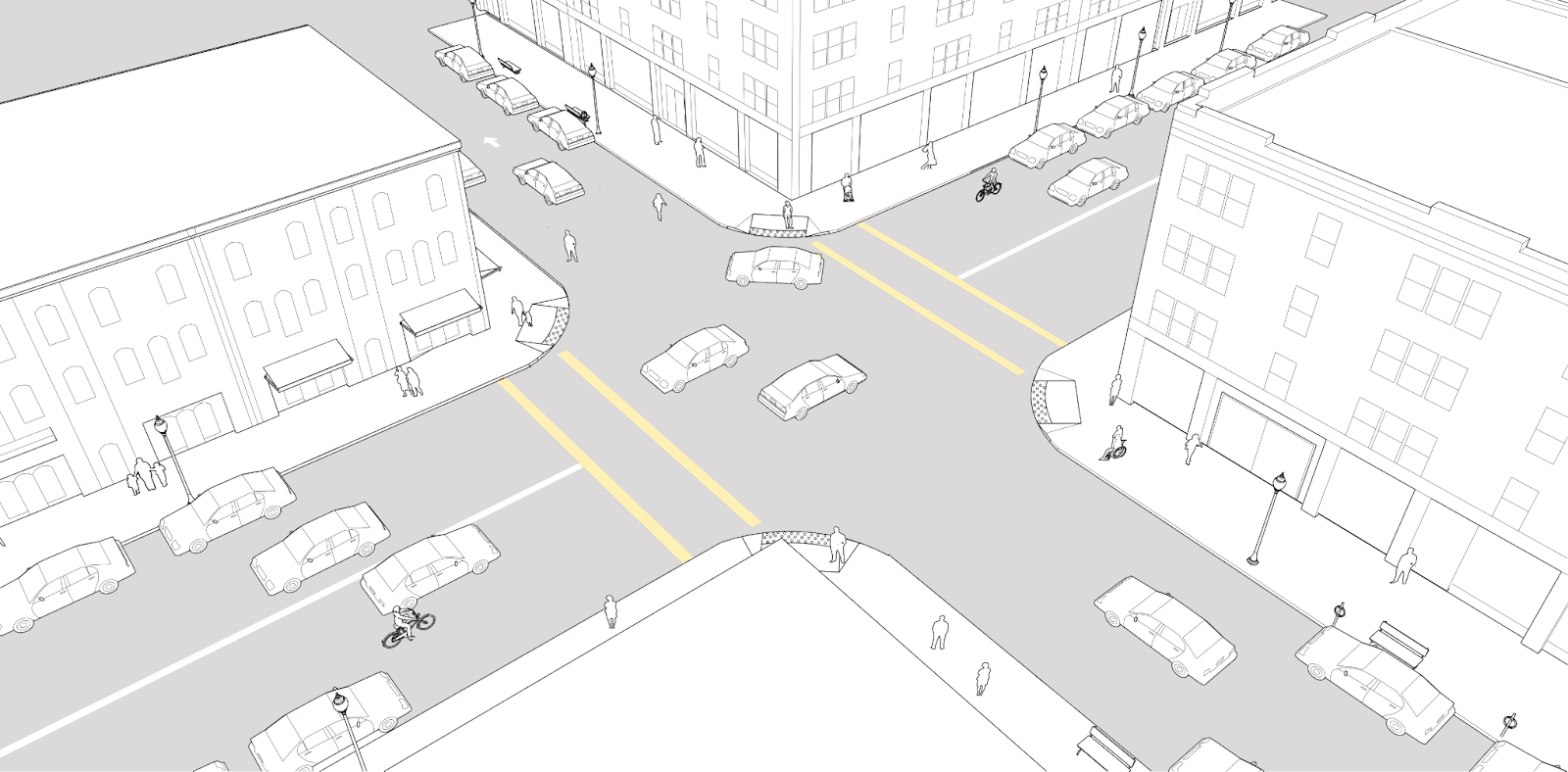
Many signalized intersections in Spokane have this style of crosswalk. Image credit: NACTO Urban Street Design Guide
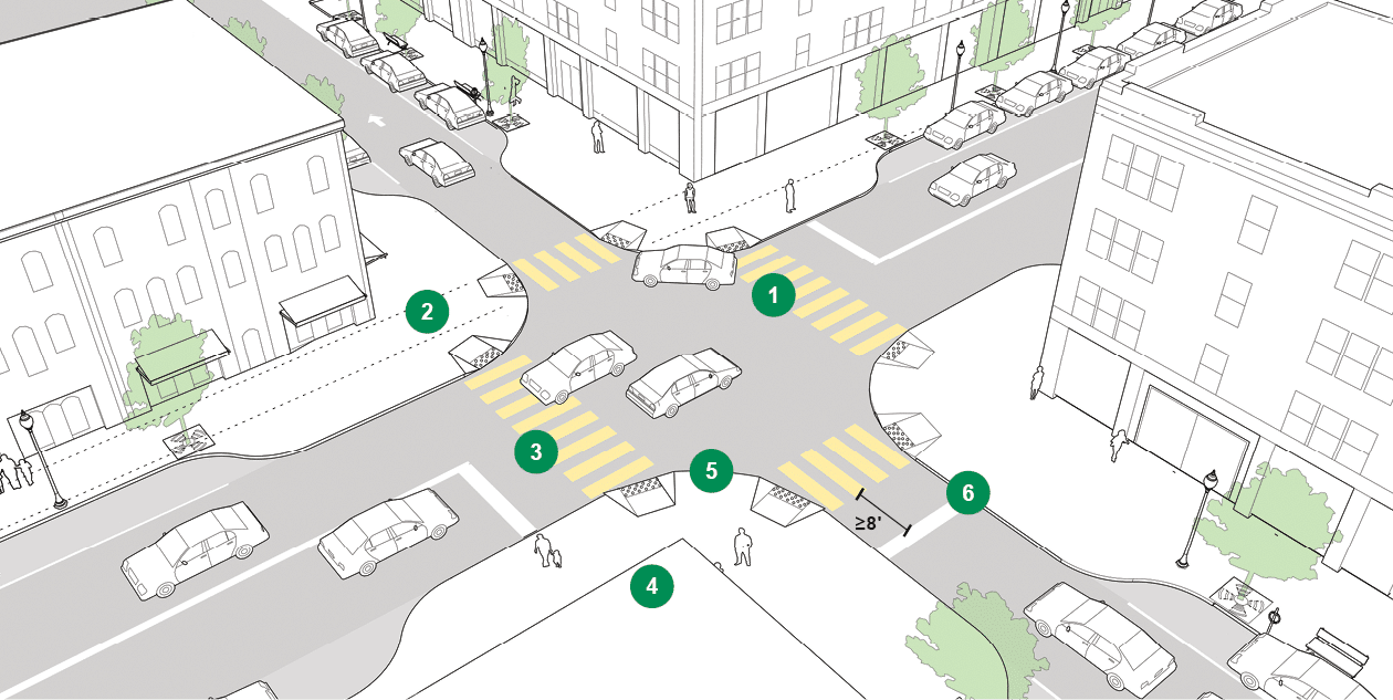
Continental-style crosswalks the city will install at 30 signalized intersections. Image credit: NACTO Urban Street Design Guide
2. Sidewalk infill on Driscoll Boulevard from Garland Avenue to Wellesley Avenue
This section of Driscoll is served by Spokane Transit Authority’s Route 33, which STA intends to transform into a High Performance Transit line in the next few years. Having sidewalks in the area is crucial for both able-bodied and disabled folks alike to access bus stops and all other destinations. Construction is planned for 2026.
3. Sidewalk and ramp infill around schools
It’s not clear exactly where these improvements would happen, but the city is planning to spend about $1.8 million next year to spruce up sidewalks and improve accessibility around some of our local schools. This is distinct from school-specific projects that follow.
4. Fixing Assembly Street and Wellesley Avenue for safer access to Flett Middle School
This intersection is an odd duck: it’s a four-way stop controlling Assembly Street’s two south-bound lanes and two north-bound lanes where they cross Wellesley Avenue, and the bike lanes disappear two blocks north of the intersection and reappear again one block south. Additionally, there are no sidewalks from Wellesley Avenue’s south side between the intersection and the school. This project will bridge the bike lane gap, install sidewalks and install a new traffic signal. Construction is scheduled for 2027.
5. Right-sizing Grand Boulevard for Sacajawea Middle School
Grand Boulevard sports three, four and sometimes five lanes in this section of street between 29th and 37th, and the city plans to reduce lane widths, add bike lanes, and improve one of the intersections to enable safer walking routes to the middle school. Construction is scheduled for 2027.
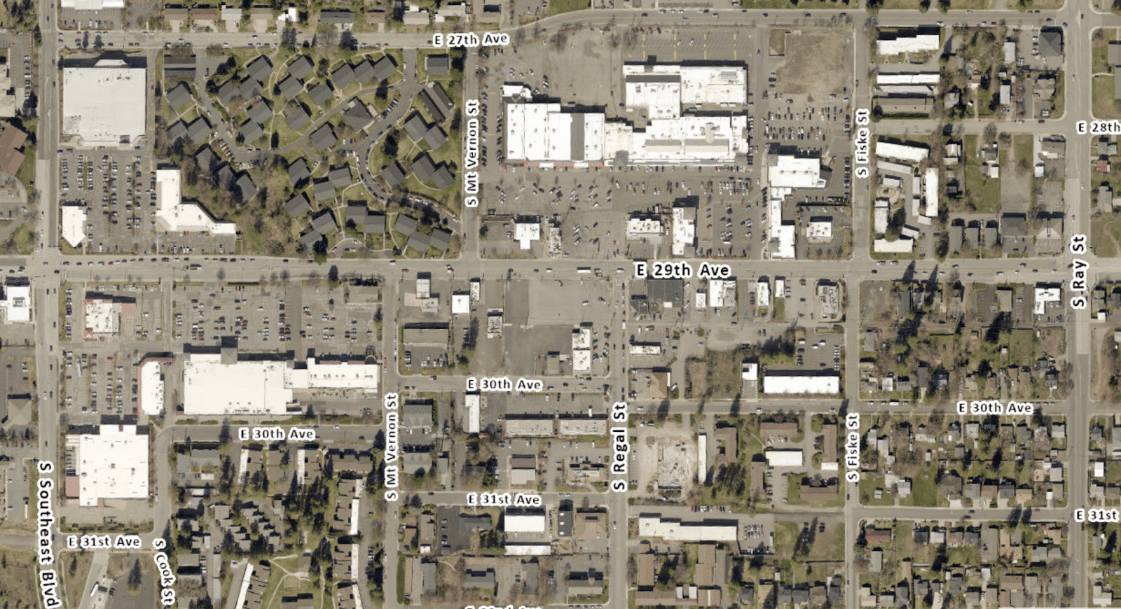
6. Adding bike lanes to 29th Avenue between Southeast Boulevard and Ray Street
While there aren’t bike lanes east and west of this stretch of 29th Avenue, lanes here would provide connection between Southeast Boulevard – a popular cycling route – and what is likely a RANGE reader favorite: the South Hill Trader Joe’s. In addition to creating safer conditions for those on bikes, narrowing the roadway from four to three lanes should boost safety for all users, including car occupants and pedestrians.
7. Creating safer access to Division Bus Rapid Transit stops
When STA transforms Route 25 into a BRT line, safe walking and cycling routes to and from stops will become even more crucial. The Division Connects Study identified a suite of improvements worth making (some of which have already been made, like the enhanced crosswalks at Longfellow Avenue and Weile Avenue). One suggestion involves protecting the existing bike lane on Rowan Avenue. Importantly, these improvements are not yet funded, but adding it to the street plan shows meaningful commitment to the projects. The city is estimating the suite will cost $14.3 million.
8. A city-wide bike boulevard network, also known as 27 by 2027
Unfortunately, this landmark project is only partially funded as the city seems to be chasing around $7 million of grant funding. The estimated cost for the network is now at roughly $8.5 million, and it seems most of the construction is expected in 2027, so perhaps a better name is “27 in 2027.” In the spirit of fairness, it seems like at least a couple segments will be built this year: the Elm Street Greenway and a two-way cycle track on Belt Street near Shadle Park.
9. New traffic signals where Rowan Avenue meets Maple Street and Ash Street
Rowan Avenue is a decent east-west connector for cycling, but without traffic signals nor enhanced crosswalks, the high speeds and traffic volume on Maple and Ash Streets can make crossing on foot or on a bike difficult. This project looks to turn Rowan Avenue’s crossings with Maple Street and Ash Street into full signalized intersections.
While this project is mostly car infrastructure — and therefore more expensive than it would need to be if it solely served pedestrians and those on bikes — these added traffic signals will make crossing these arterials easier for everyone. Construction is scheduled for 2026 and is, in part, funded by the Safe Streets for All Fund (previously known as the Traffic Calming Fund).
10. Studying a one-way to two-way conversion of Haven and Market Streets through Hillyard
In decades past, two-way streets were converted to one-ways under the guise of faster vehicle movement through an area. And for decades, the couplet of Haven and Market Streets has been a freight corridor, but planners hope most freight traffic will move to the North Spokane Corridor once it is complete.
Planners and researchers are realizing the detrimental effects one-way streets have in urban areas: those on bikes and those on foot are less safe and businesses suffer. After all, drivers passing through don’t spend money at businesses, only people coming in the door do. This project funds a study, not construction, but the evidence is clear that one-ways harm the type of neighborhood center we all want central Hillyard to be.
11. Downtown Sprague Avenue rebuild, a la Riverside Avenue rebuild of 2022
Riverside Avenue was rebuilt in 2022 to allow for utility work, but created some of the city’s first protected bike lanes as well as City Line stops. This project on Sprague Avenue from Division Street to Post Street has similar themes.
Here’s the description: “Initiate project planning to define scope of work. Anticiapted (sic) to be a collaborative project with STA to incorporate HPT stop improvements. Potential improvements include full street reconstruction, traffic signal replacement, lane configuration and cross section revisions, sidewalk and ADA ramp improvements along with utility replacements and upgrades.”
STA’s Connect 2035 plan for Sprague Avenue includes an initiative to transform Route 9 – the Sprague route – into a high performance transit line, and of course the south side of the STA plaza sits on Sprague, so several west-bound routes use this corridor and could benefit from better bus infrastructure.
Construction is scheduled for 2030 and 2031 as of now, but it’s quite common for street plan projects to get pushed out over the years. The project is only partially funded.
12. Traffic control and a shared-use path at Ferris High School, 65 years in the making
The city plans to add a signal or roundabout at 37th Avenue and Ray Street – the main entrance to Ferris High School. Plans also include a new traffic signal at 37th Avenue and Freya Street and a shared use path in the area.
Plans for traffic revisions in this area date back to 1966, but were adjusted in 1986, removed from the street plan in 2017, studied again in 2021 and added back into the plan this year with a construction date of 2031. 2031 will be the 65th anniversary of the initial plans.
Several different concepts have been planned and studied over the years. The city owns a diagonal swoop through Ferris, sometimes considered for a street, and more recently for a shared use path. The city also owns eight parcels near 37th Avenue and Ray Street, which were purchased over the years in anticipation of needing more right of way for whichever traffic revision was landed on.
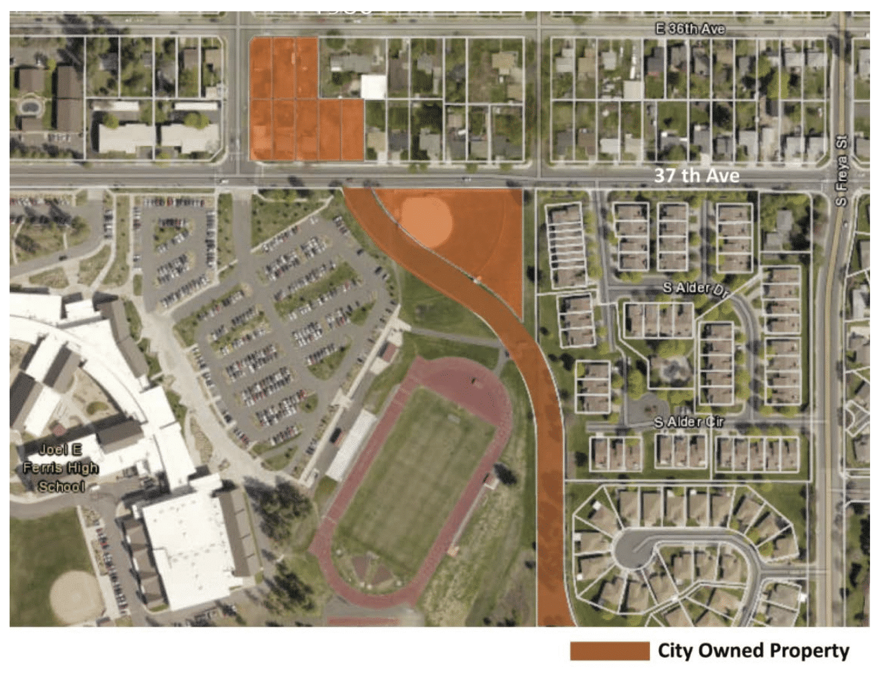
Source: Ray-Freya Alternatives Report
Those are the shiny new projects that were just added, but there’s still some excitement (and disappointment) in the edits planners made to projects that were previously included.
Major bike, ped and transit projects changed in the plan
1. The Spokane Falls Boulevard rebuild was estimated in the 2025 plan to cost $11.5 million, but sports a $14 million price tag in the 2026 plan.
2. Fish Lake Trail - Phase 3b, which would bridge the roughly one mile gap between the north and south sections of the beloved trail that connects Spokane to Cheney, was estimated in previous years’ plans to cost around $6 million, but is now estimated at $10.7 million.
3. Fish Lake to Centennial Trail Connection - Phase 2, which would connect Sandifur Bridge to a trail paralleling Government Way, was scheduled for construction in 2026 and 2027 in the 2024 street plan, but is now scheduled for construction in 2027 and 2028.
4. The Latah Bridge Rehabilitation, which will replace the bridge deck and certain structural elements, was estimated in the 2024 plan to cost $49 million. This year’s plan lists it at $65 million. STA has historically requested that the bridge rehab take into account the weight of a light rail line to the West Plains.
5. The street plan has included a project to study (not build) a protected bike lane on Boone. The study was scheduled for 2024, then 2025 and now 2026. It’s part of the Division Connects suite of recommended active transportation projects, but has met pushback from local leaders over concerns about traffic leaving the Spokane Arena after events.
6. Pacific Avenue Greenway - Phase 1, which will run from Howard to Sherman, was scheduled to be constructed in 2026, according to the 2024 street plan. The 2026 street plan now estimates that construction will bleed into 2027, and adds about $1 million to the overall cost.
7. Pacific Avenue Greenway - Phase 2, which will connect Sherman to the Ben Burr Trail, has increased in price from $4 million in the 2024 plan to $7 million in today’s plan.
Lastly, active transportation projects removed from the plan
Projects are removed when they are complete, or if they are expected to complete this calendar year.
- Post Street Bridge
- Scott Elementary Safe Routes to School
- Stevens Elementary Safe Routes to School
- Lincoln Street Pedestrian and Bike Safety
- Maxwell Avenue – Pettet to Walnut Bike/Pedestrian Safety Upgrades
A note from Lauren: If you find yourself wanting to track what bike infrastructure is getting built and when, whether by the city of Spokane or by others, you might enjoy my project tracking tool. It’s been updated with the 2026-2031 Six Year Street Plan from the City of Spokane. I’ll update it with this year’s plans from the County, Spokane Valley and the other small cities when those become available.


